
Mudeungsan 1,187m
The Face of Gwangju, the City of Light
Easy Moderate Hard Public transport


- Location
- Dong-gu, Gwangju; Nam-myeon, Damyang-gun and Iseo-myeon, Hwasun-gun, Jeollanam-do
- Courses
- 31 · 2 h 5 min – 7 h 15 min
- Distance
- 5.4 km – 18.8 km
- Facilities
- Toilets 31 · Parking 25
- Managed by
- Buk-gu Office · 062-410-8000
Trail map
- Directions to trailhead
- Directions to trailhead
- Directions to trailhead
- Directions to trailhead
- Directions to trailhead
- Directions to trailhead
- Directions to trailhead
- Directions to trailhead
- Directions to trailhead
- Directions to trailhead
- Directions to trailhead
- Directions to trailhead
- Directions to trailhead
- Directions to trailhead
- Directions to trailhead
- Directions to trailhead
- Directions to trailhead
- Directions to trailhead
- Directions to trailhead
- Directions to trailhead
- Directions to trailhead
- Directions to trailhead
- Directions to trailhead
- Directions to trailhead
- Directions to trailhead
- Directions to trailhead
- Directions to trailhead
- Directions to trailhead
- Directions to trailhead
- Directions to trailhead
- Directions to trailhead
Why it is one of the 100 famous mountains
Selected for its magnificent scenery of bizarre rocks featuring well-developed columnar joints near Cheonwangbong Peak, its role as a retreat for city residents, and its designation as a provincial park (1972). It is also famed for temples like Jeungsimsa, home to the Iron Seated Vairocana Buddha (Treasure No. 131), and Wonhyosa.
About Mudeungsan
Mudeungsan is a solitary mountain with indistinct ridges and valleys, resembling a massive mound. Its most prominent features are the talus slopes (boulder fields); the Jigong Neodeol south of Cheonwangbong Peak and the Deoksan Neodeol east of Jeungsimsa Temple are magnificent sights.
The summit where rocks of all shapes gather, centered on Cheonwangbong Peak, boasts a grandeur that proves it has long been a sacred mountain revered by the people of the Namdo region. In particular, the rock formations of Ipseokdae, Seoseokdae, and Gyubong are awe-inspiring. However, Mudeungsan generally has gentle slopes and consists mostly of earthen terrain.
Viewed from afar, its panoramic silhouette resembles the Chinese character for mountain (山), rising at the heart of the Honam Jeongmaek ridge. Its valleys harbor clear, deep waters that have served as the lifeline of Gwangju. With a location and topography second to none in the southern region, it is more than fitting as the mountain that embraces the City of Light, Gwangju.
Located just 10 km east of downtown Gwangju, Mudeungsan is designated as a provincial park.
Because the mountain terrain is not rugged and is mostly composed of soil, it is easy for anyone to climb, with clear streams flowing throughout. Grand rock formations such as Seoseokdae, Gyubong, and Ipseokdae grace the upper sections, while famous temples like Yaksaam Hermitage, Jeungsimsa Temple, and Wonhyosa Temple nestle at the foot and mid-slopes. It was designated as a provincial park in 1972, and various recreation and convenience facilities are established at the base.
Courses recommended by the Korea Forest Service
- Wonhyosa Temple → Donghwasateo Site → Jungbong Peak → Seoseokdae Rock → Ipseokdae Rock → Jangbuljae Pass → Anyangsan → Dunbyeongjae Pass 4 h 30 min
- Yeongpyeong-ri → Gyubongam Hermitage → Jangbuljae Pass → Ipseokdae Rock → Seoseokdae Rock → Jungbong Peak → Baramjae Pass → Jeungsimgyo Bridge 5 h 30 min
- Sinjeongam Hermitage, Hwasun-eup → Jungmeorijae Pass → Jangbuljae Pass → Kkomakjae Pass → Mudeungsanjang 7 h
Public transport
The starting point is Gwangju.
There are many city buses heading to Mudeungsan from downtown Gwangju. To head toward Jeungsimsa Temple, take Bus 17 or 222 from Gwangju Station, get off at the Provincial Government Office, and transfer to Bus 15 or 555.
- Provincial Government Office → Jeungsimsa District: Bus 15, 555,
Gwangju Public Transit Division ☎062-613-4511~8
- Provincial Government Office → Wonhyosa District: Bus 1187
Food, lodging & more (Korea Forest Service data, may change)
● Food, Lodging, and Other Info
The areas around Jeungsimsa Temple and Wonhyosa Temple are collective tourist facility zones with plenty of places to eat and stay.
Mudeung Park Hotel ☎062-226-0011
Unrim Sikdang ☎062-226-5479
Mudeungjip ☎062-222-7531, etc.
● Inquiries
Mudeungsan Park Management Office Wonhyosa District ☎062-265-0761, Jeungsimsa District ☎062-225-9993
Nearby attractions
- Gyubongam Hermitage (Hwasun) (규봉암(화순)) 1.4 km from the summit
-
 Mudeungsan National Park (Gwangju) (무등산국립공원(광주))
2.9 km from the summit
-
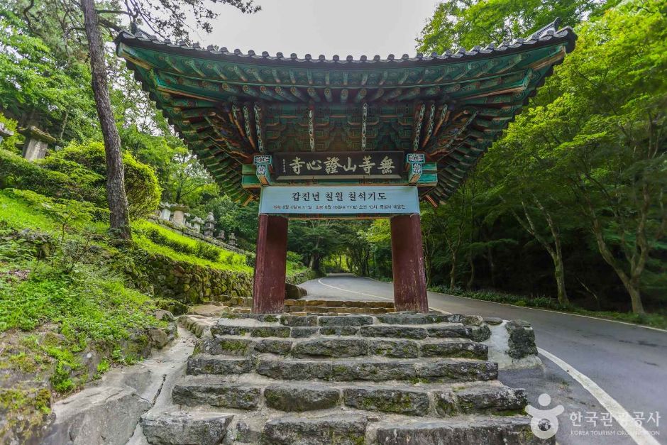 Gwangju Jeungsimsa Temple (증심사(광주))
3.1 km from the summit
-
 Uijae Museum of Korean Art (광주 의재미술관)
3.4 km from the summit
- De Young Museum (드영미술관) 4.8 km from the summit
- Chungjangsa Shrine (충장사) 5.1 km from the summit
Times and difficulty are estimates from GPS tracks. Before you go, check the weather, sunset time and any trail closures. Course tracks recorded: 2022-01-06
Text on this page was translated automatically from Korean public data. Place names follow the Revised Romanization; signs on the trail are in Korean.
Data: Korea Forest Service and Korea Hiking & Trekking Support Center (Public Data Portal). Course times and difficulty are estimates from GPS tracks (2022).