
Mireuksan 458m
Center of Maitreya Faith Preserving Traces of Beacon Mound
Easy Moderate Spring flowers Valleys Autumn foliage Sea views Public transport


- Location
- Sanyang-eup and Bongpyeong-dong, Tongyeong-si, Gyeongsangnam-do
- Courses
- 6 · 2 h 50 min – 4 h 5 min
- Distance
- 6.8 km – 9.4 km
- Facilities
- Toilets 6 · Parking 7
- Managed by
- Tongyeong City Hall · 1577-0557
Trail map
Why it is one of the 100 famous mountains
Rising at the center of Mireukdo Island, which is linked to Chungmu-si by a bridge, this mountain was selected for its scenic beauty, offering panoramic views of Hallyeohaesang National Park. It is marked as Yonghwasan on topographic maps and is home to Yonghwasa Temple, which preserves a Stone Seated Buddha (Gyeongsangnam-do Tangible Cultural Heritage No. 43) as well as statues of Ksitigarbha Bodhisattva and the Ten Kings of the Underworld from the mid-Goryeo period. It is also famous for Dosoram Hermitage, founded by Buddhist Master Dosol, Gwaneumsa Temple, and the remains of a beacon fire station.
About Mireuksan
A majestic mountain rising in the center of Mireukdo Island, south of Tongyeong-si. It is also called Yonghwasan because the ancient temple Yonghwasa is located here, and both Mireuksan and Yonghwasan are used in reference to the Yonghwa Assembly where Maitreya Buddha is said to descend in the future.
At its foot are the ancient temple Yonghwasa, along with hermitages Gwaneumam and Dosoram, and Miraesa Temple, the birthplace of the Hyobong lineage. Though not very high, it possesses all the virtues of a renowned mountain, featuring clear streams flowing through lush forests, uniquely shaped rocks, and rock caves.
Its ancient temples, spring water, spring azaleas, and autumn foliage are outstanding. From the summit, the view of the archipelago across Hallyeohaesang National Park is indescribably beautiful, and on clear days, Tsushima Island in Japan can be seen.
Located on Mireukdo Island at the southwestern end of Tongyeong-si, it is a low mountain but widely recognized among Buddhists as the center of Maitreya faith. Perhaps for this reason, this small mountain is home to numerous large and small temples and hermitages, including Yonghwasa Temple, Gwaneumsa Temple, Dosoram Hermitage, and Miraesa Temple.
In addition, the summit, called Imhaebong Peak, is historically significant as a former beacon mound that guarded the archipelago. Mireuksan is connected to Tongyeong—Korea's finest port city and the site of Admiral Yi Sun-sin's famous naval victory over Japanese forces—via the nation's only undersea tunnel. Known as "Pandaegul," this undersea tunnel was built by the Japanese during the colonial period and remains in use long past its expected lifespan, drawing interest as an example of engineering from that era.
Reaching the summit offers an astonishingly beautiful panoramic view of large and small islands, including Bijindo, Geojedo, Hansando, and Chilcheondo, which adorn the Hallyeosudo waterway like jewels.
Courses recommended by the Korea Forest Service
- Yonghwasa Square → Gwaneumsa Temple → Dosoram Hermitage → Summit → Ttibatdeung → Yonghwasa Temple → Yonghwasa Square 1 h 40 min
- Yonghwasa Square → Gwaneumsa Temple → Dosoram Hermitage → Summit → Miraesa Temple → Yeongun-ri 2 h 20 min
Public transport
The starting point is Tongyeong.
- Tongyeong → Yonghwasa: Take city bus No. 20 or 21
Food, lodging & more (Korea Forest Service data, may change)
● Lodging and Other Information
Numerous accommodations are available in downtown Tongyeong and the Mireukdo Special Tourist Zone.
Chungmu Tourist Hotel ☎ 055-645-2091
Tongyeong Tourist Hotel ☎ 055-644-4411
Chungmu Beach Hotel ☎ 055-641-8181
Geumseong Motel ☎ 055-649-3335
● Inquiries
Tongyeong City Tourism Promotion Division ☎ 055-645-0101
Nearby attractions
-
 Napory Farm in Tongyeong (통영 나폴리농원)
1.3 km from the summit
- Pak Kyongni Memorial Hall (박경리 기념관) 1.5 km from the summit
-
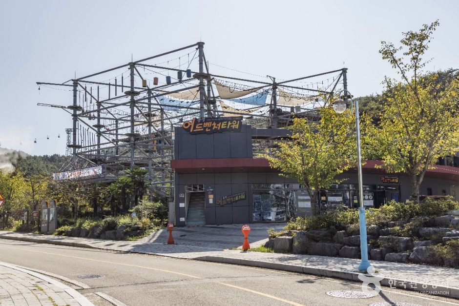 Tongyeong Adventure Tower (통영어드벤처타워)
1.6 km from the summit
-
 The Jeon Hyuck Lim Mueseum of Art (전혁림 미술관)
1.7 km from the summit
-
 Hansan Marina Yacht (한산마리나요트)
1.8 km from the summit
-
 Tongyeong Cable Car (통영케이블카)
1.9 km from the summit
Times and difficulty are estimates from GPS tracks. Before you go, check the weather, sunset time and any trail closures. Course tracks recorded: 2022-01-06
Text on this page was translated automatically from Korean public data. Place names follow the Revised Romanization; signs on the trail are in Korean.
Data: Korea Forest Service and Korea Hiking & Trekking Support Center (Public Data Portal). Course times and difficulty are estimates from GPS tracks (2022).