
Jangansan 1,237m
Moderate Valleys Autumn foliage Silver grass Public transport


- Location
- Gyenam-myeon and Jangsu-eup, Jangsu-gun, Jeollabuk-do
- Courses
- 1 · 3 h 20 min – 3 h 20 min
- Distance
- 8.5 km – 8.5 km
- Facilities
- Toilets 1 · Parking 0
- Managed by
- Jangsu County Office · 063-351-2141
Trail map
Why it is one of the 100 famous mountains
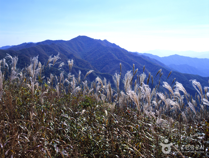
Selected for its designation as a County Park (1986) thanks to Deoksan Valley and other large and small valleys, ponds such as Uityongso and Araetyongso, and unique rock formations harmonizing with the forest. It is also famous for the expansive silver grass field stretching across its eastern ridge and for Deoksan Yongso Valley.
About Jangansan
Jangansan is the primary mountain of the Honam region that commands the Geumnamjeongmaek and Honamjeongmaek ridgelines, delivering the energy of Baekdudaegan to Chungcheong-do and Jeolla-do. Celebrated as a cool retreat in summer and known for silver grass and autumn foliage in autumn, its scenic valleys and forests led to its designation as a Jangsu-gun County Park in 1986. The mountain boasts picturesque sights including 26 large and small valleys, 7 ponds, 14 rock formations, 5 mineral springs, and waterfalls. Its eastern ridge features a vast silver grass field that blankets the mountain crest in autumn.
There are several trailheads for Jangansan, but entering the trail on the way from Deoksan Valley to Beomnyeon-dong is recommended. A trail map and restrooms are available at the trailhead.
Jangansan is a prominent peak rising at the beginning of the Honamjeongmaek ridgeline, which branches west from Yeongchwisan on the Baekdudaegan along the border of Jangsu-gun and Hamyang-gun. Bordered by the Seomjin River and Geum River, Jangansan's range spans across Honam and Hoseo, covering approximately 25% of the national territory as an ancestral and sacred mountain. It is the tallest mountain along this range and the fourth highest mountain in the Honam region following Jirisan, Deogyusan, and Namdeogyusan.
Designated as a County Park in 1986, Jangansan features unique rock formations and dense primeval forests. It is divided into the Deoksan Yongso, Banghwadong, and Jiji Valley districts, offering superb natural scenery.
Courses recommended by the Korea Forest Service
- Muryeonggogae Pass → Summit → Jungbong Peak → Habong Peak → Eochijae Pass → Beomnyeon-dong 3 h 50 min
- Muryeonggogae Pass → Summit → Jungbong Peak → Deokcheon → Confluence Point → Yeonju 4 h 55 min
Public transport
The starting point is Jangsu. Buses from Jangsu to Deoksan-ri run twice a day (08:35, 16:30); a taxi costs around 10,000 KRW. There is no direct public transportation to Muryeonggogae Pass, so you must take a bus to Goemok or Daegok-ri below the pass and walk up. Local buses from Gyenam-myeon to Goemok run 6 times a day. Buses from Janggye-myeon to Daegok-ri run 4 times a day.
Food, lodging & more (Korea Forest Service data, may change)
● Accommodation and Other Info
Guesthouses, mountain lodges, and campgrounds are located near Deoksan Valley.
Nongae Training Center (☎063-352-1374), located near the Birthplace of Nongae, is a large accommodation facility converted from a closed school.
Mudeuri Mountain Lodge (☎063-351-8487) at the entrance of Deoksan Valley also serves meals.
● Inquiries
Jangansan County Park Management Office, Jangsu County Office Forestry Division (☎063-351-8515, 350-2413~4)
Nearby attractions
 Jangansan County Park (장안산군립공원)
Times and difficulty are estimates from GPS tracks. Before you go, check the weather, sunset time and any trail closures. Course tracks recorded: 2022-01-06
Text on this page was translated automatically from Korean public data. Place names follow the Revised Romanization; signs on the trail are in Korean.
Data: Korea Forest Service and Korea Hiking & Trekking Support Center (Public Data Portal). Course times and difficulty are estimates from GPS tracks (2022).