
Hwawangsan 758m
A garden of royal azaleas in spring, a field of silver grass in autumn
Easy Moderate Spring flowers Valleys Autumn foliage Snow scenery Silver grass


- Location
- Goam-myeon and Changnyeong-eup, Changnyeong-gun, Gyeongsangnam-do
- Courses
- 5 · 1 h 45 min – 4 h 45 min
- Distance
- 3.5 km – 11.1 km
- Facilities
- Toilets 15 · Parking 13
- Managed by
- Changnyeong County Office · 055-530-1000
Trail map
Why it is one of the 100 famous mountains
Selected for its scenic beauty featuring silver grass fields and azalea colonies, its historical sites including Hwawangsanseong Fortress and Mokmasanseong Fortress, and its status as a county park. A full-moon welcoming event is held on the silver grass plateau near the summit every Jeongwol Daeboreum (First Full Moon of the Lunar Year). The summit has three crater ponds (Yongji) formed by volcanic activity. Notable attractions also include the Songhyeon-dong Ancient Tombs and Gwallyongsa Temple, which houses four designated treasures including a stone seated Buddha statue and Daeungjeon Hall.
About Hwawangsan
Serving as the guardian mountain of Changnyeong-eup, Hwawangsan forms Hwawangsan County Park along with Gwallyongsan. Hwawangsan is synonymous with silver grass. About 60,000 pyeong of vast plains form a 4-kilometer-long field of silver grass, which grows well above human height. It takes just over an hour to loop around this field.
In autumn, one of the country's largest night festivals takes place here. Gathered by about 10,000 people from all over the nation, memorial rituals for mountain spirits and righteous army soldiers as well as torchlight marches praying for reunification are held, presenting a spectacular sight. Hwawangsan is also famous for azaleas. Along the 6.5 km ridge hiking trail connecting to the summit of Gwallyongsan, azaleas bloom continuously.
Located in Changnyeong, Gyeongsangnam-do, Hwawangsan is a rugged mountain.
It is especially well known for azaleas and royal azaleas in spring, lush greenery and valleys in summer, silver grass in autumn, and snowscapes in winter. The spring azaleas and autumn silver grass are particularly famous; in spring, the slopes surrounding Hwawangsanseong Fortress and the ridge towards Gwallyongsan look as if covered in pink paint. From late April to early May each year, the entire mountain is engulfed in vivid reddish pink blooms.
The mountain's greatest highlight is the expansive, flat silver grass field near the summit. Along the ridge line where this plateau drops sharply into steep cliffs stands the wall of Hwawangsanseong Fortress, and nearly all outer slopes are covered with azaleas. Every October, the Hwawangsan Silver Grass Festival is held here. Hwawangsan is presumed to have been a prehistoric volcano and features three crater ponds (Yongji). Within Hwawangsanseong Fortress (Historic Site No. 64) is a monument marking the birthplace of the Changnyeong Jo clan. Mokmasanseong Fortress (Historic Site No. 65) can be seen on the western ridge, and Gwallyongsa Temple lies about 5 km east along the ridge.
Courses recommended by the Korea Forest Service
- Changnyeong-eup → Doseongam Hermitage → Hwanjanggogae Pass → Summit → Mokmasanseong Fortress → Changnyeong Girls' High School 3 h
- Changnyeong-eup → Doseongam Hermitage → Summit → Hwanjanggogae Pass → 755.8m Peak → Pavilion → Ticket Office 2 h 50 min
Public transport
The base point is Changnyeong.
Changnyeong-eup → Okcheon-ri: runs 6 times a day
Food, lodging & more (Korea Forest Service data, may change)
● Lodging and other info
There are no accommodations in Okcheon-ri, the trailhead for Gwallyongsan, but there are many inns in Changnyeong-eup, the trailhead for Hwawangsan.
Mokhwa Jang Motel (055-532-0566)
Sinil Jang (055-532-1255)
Hwawang Sanjang (055-532-1069)
Bisabeol Motel (055-532-0609)
● Inquiries
Okcheon Ticket Office: 055-530-2498
Nearby attractions
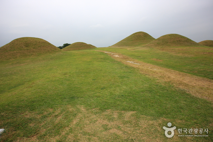 Ancient Tombs in Gyo-dong and Songhyeon-dong, Changnyeong (창녕 교동과 송현동 고분군)
Times and difficulty are estimates from GPS tracks. Before you go, check the weather, sunset time and any trail closures. Course tracks recorded: 2022-01-06
Text on this page was translated automatically from Korean public data. Place names follow the Revised Romanization; signs on the trail are in Korean.
Data: Korea Forest Service and Korea Hiking & Trekking Support Center (Public Data Portal). Course times and difficulty are estimates from GPS tracks (2022).