
Hwangmaesan 1,113m
Three peaks reached along ranch trails
Easy Moderate Spring flowers Silver grass Public transport


- Location
- Gahoe-myeon and Daebyeong-myeon, Hapcheon-gun; Chahwang-myeon, Sancheong-gun, Gyeongsangnam-do
- Courses
- 4 · 1 h – 4 h
- Distance
- 2.4 km – 9.7 km
- Facilities
- Toilets 2 · Parking 1
- Managed by
- Hapcheon-gun Office · 055-930-3114
Trail map
Why it is one of the 100 famous mountains
Selected for its scenic beauty created by the harmony of granite rock formations, pine trees, royal azaleas, and broadleaf forests. It is also called 'Sujungmae' because the reflections of its three peaks—Habong, Jungbong, and Sangbong—in the blue waters of Hapcheonho Lake resemble three plum blossoms in water. Below the peak, Hwangmae Plateau features ranch pastures and high-mountain royal azalea habitats, along with Yeongamsaji Temple Site (Historic Site No. 131), an ancient temple site from the Unified Silla era.
About Hwangmaesan
Passing along the shore of Hapcheonho Lake, a magnificent mountain rises against the southern skyline. Striking rocky peaks reflect in the lake water, leaving visitors in awe that such a high mountain exists nearby. Opening a map reveals Hwangmaesan. Beyond its striking skyline, this county park is famous for silver grass and royal azaleas.
Its dramatic landscape served as the filming location for two major hit movies, hosting battlefield scenes along the Nakdonggang defense line and fantasy martial arts action that highlights its quintessential Korean terrain.
Along the main ridge stretches Hwangmae Plateau, broader than Sinbul Plains. Once home to twelve ranches, only two remain today while the rest lies bare like wild heathland. When spring arrives, clusters of vibrant royal azaleas bloom across this vast plateau.
Hwangmaesan (1,108m), often referred to as 'Sujungmae' (plum blossom in water) because its three peaks—Habong, Jungbong, and Sangbong—resemble plum blossoms submerged in the blue waters of Hapcheonho Lake, is located 20 km southwest of Hapcheon-eup.
Beneath the mountain, Hwangmae Plateau hosts ranch pastures and natural high-mountain royal azalea habitats, along with the historic site of Yeongamsaji Temple Site (Historic Site No. 131) from the Unified Silla era. Designated a county park in 1983, a hiking trail was established from Dunnae-ri in Gahoe-myeon to Yeongamsaji Temple Site. A campsite is also operated at Hageumcheon Stream in Hageum-ri, Daebyeong-myeon, serving visitors to Hapcheonho Lake and the mountain area.
Courses recommended by the Korea Forest Service
- Jangbak-ri → Tteokgaljae Ridge Junction → Neobaegi → Peak → Hwangmaesan Altar → Beteulbong Peak → Royal Azalea Altar → Ranch → Deokman-ri 4 h 25 min
- Hageum Campsite → Tteokgaljae → Neobaegi → Peak → Hwangmaesan Altar → Beteulbong Peak → Cheonhwangjae → Gamamsan → Seongjidongcheon → Sinchon-ri 4 h 50 min
- Deokman-ri → Sambong → Habong → Jungbong → Hwangmaebong Peak → Northwest Ridge Junction → Movie Theme Park 4 h
Public transport
Hapcheon serves as the starting point for Gahoe-myeon and Daebyeong-myeon, while Sancheong is the gateway for Chahwang-myeon.
For Gahoe-myeon, take a Jinju-bound direct bus from Hapcheon (14 times daily), get off at Samga, and take a taxi. For Daebyeong-myeon, local buses run at 50-minute intervals.
For Chahwang-myeon, local buses run from Sancheong 15 times daily, including 9 buses bound for Jangbak-ri and 4 bound for Sinchon.
Food, lodging & more (Korea Forest Service data, may change)
● Food, Lodging, and Other Info
Due to the remote location, visitors typically stay in minbak accommodations attached to local restaurants at the foot of the mountain.
Gahoe-myeon side: Hwangmaesan Restaurant ☎ 055-931-1367 / 011-853-4342, Mosanjae Restaurant ☎ 055-933-1101 / 016-9616-1101
Chahwang-myeon side: Hwangmae Sanjang ☎ 055-973-8817 / 011-879-3304, Togung Sanjang ☎ 016-598-1262
● Inquiries
Hwangmaesan County Park Management Office ☎ 055-930-4151
Nearby attractions
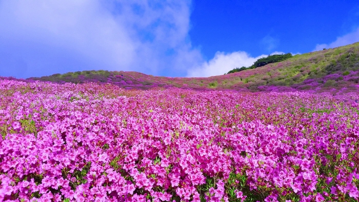 Hwangmaesan County Park (황매산군립공원)
 Hapcheonho Lake (합천호)
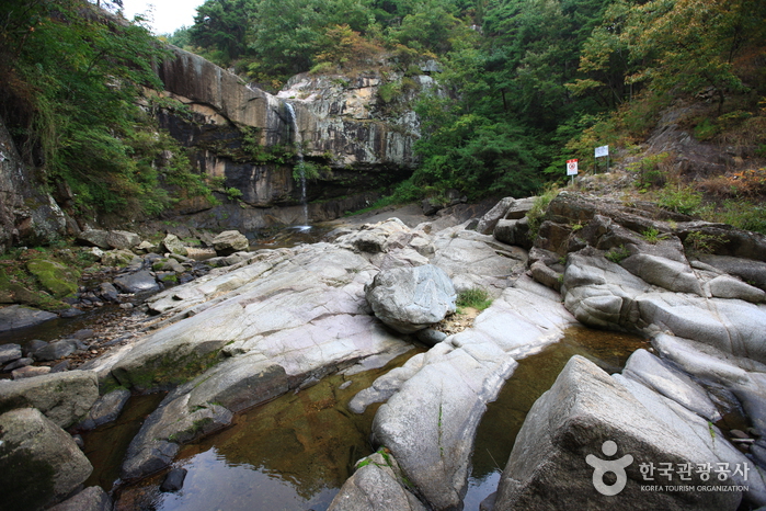 Hwanggyepokpo Falls (황계폭포)
Times and difficulty are estimates from GPS tracks. Before you go, check the weather, sunset time and any trail closures. Course tracks recorded: 2022-01-06
Text on this page was translated automatically from Korean public data. Place names follow the Revised Romanization; signs on the trail are in Korean.
Data: Korea Forest Service and Korea Hiking & Trekking Support Center (Public Data Portal). Course times and difficulty are estimates from GPS tracks (2022).