
Gitdaebong 368m
Easy Spring flowers Sunrise Sea views


- Location
- Hongdo, Heuksan-myeon, Sinan-gun, Jeollanam-do
- Courses
- 1 · 2 h 10 min – 2 h 10 min
- Distance
- 5.1 km – 5.1 km
- Facilities
- Toilets 1 · Parking 0
- Managed by
- Sinan County Office · 061-271-1004
Trail map
Why it is one of the 100 famous mountains
Selected for its high ecological value, including native wintergreen (Euonymus fortunei), Japanese laurel (Aucuba japonica), and camellia forests, leading to the designation of the entire island as a Natural Protection Area (1965) and Dadohaehaesang National Park (1981). True to its name, it is a rocky peak shaped like a flagpole (gitdae) and is the highest peak on Hongdo.
Gitdaebong Peak forms part of the splendid landscape of Hongdo, in harmony with coastal formations such as Dongnimmun Gate and Seokhwa Cave.
About Gitdaebong
Hongdo, a small island in Dadohaehaesang National Park and designated Natural Monument No. 170 in its entirety, is an island where Gitdaebong Peak (360.7 m) and Yangsanbong Peak (231.8 m) rise like ants. It was named Hongdo (Red Island) because the entire island consists of reddish-brown quartzite rock, and was also called Maegado because it resembles a plum blossom floating on the sea.
Hongdo is a natural tourist destination where you can enjoy swimming, scuba diving, cruise tours, and hiking. However, because its coastline is only 20.8 km long, hiking is mostly limited to crossing Gitdaebong Peak along the route formerly used by residents traveling between Hongdo Village 1 and Village 2. Taking an excursion boat from the Bbadole (pebble) beach allows you to circumnavigate the entire island and view Gitdaebong Peak from the water.
Since it is an island, ferry departures often depend on weather conditions such as typhoons, so planning 2 nights and 3 days with extra flexibility is advisable. Note that because the entire island is designated a Natural Monument, taking any plant or stone off the island is strictly prohibited. The wind orchid of Hongdo (Hongdopungnan), growing in the sea breeze, is a representative rare plant.
Located in Hongdo-ri, Heuksan-myeon, Sinan-gun, Jeollanam-do, Hongdo is an affiliated island of Daeheuksando within Dadohaehaesang National Park and is also called Maegado. Hongdo and its 20 or so surrounding islets are called the Geumgang of the South Sea for their superb scenery. Among them, the sunrise at Nokseom Islet is a spectacular sight. The scene of the sun rising between two rocks amidst rolling waves is indescribably beautiful. In addition, the sunset on Hongdo is a scenic wonder not to be missed.
Around Gitdaebong Peak (367 m above sea level), the main peak of the island, and to the south, there are dense camellia forests, Machilus thunbergii, and Aucuba japonica, hosting some 500 species of rare plants as well as around 200 species of animals and insects.
The hike up Gitdaebong Peak is extremely steep and dense with royal azaleas, camellias, and various wild trees; reaching the main peak reveals a needle-like sharp formation.
To the southwest, the connecting ridges of Yangsanbong Peak resemble an Oriental painting, while to the east, the lush forest of Seolpungseojeon is magnificent.
Public transport
The starting point is Mokpo.
> Mokpo → Hongdo: Runs twice daily
> Hongdo → Mokpo: Runs twice daily
Food, lodging & more (Korea Forest Service data, may change)
● Lodging and Info
Over 50 inns and guesthouses are clustered in Hongdo Village 1 and Village 2, capable of accommodating around 2,000 visitors at once. Most also serve breakfast.
Gwangseong Yeogwan ☎ 061-246-2094, Hongdo Yeogwan ☎ 061-246-2500, Gardenjang Minbak ☎ 061-246-2937, etc.
● Inquiries
Sinan-gun Hongdo Management Office ☎ 061-246-3700
Nearby attractions
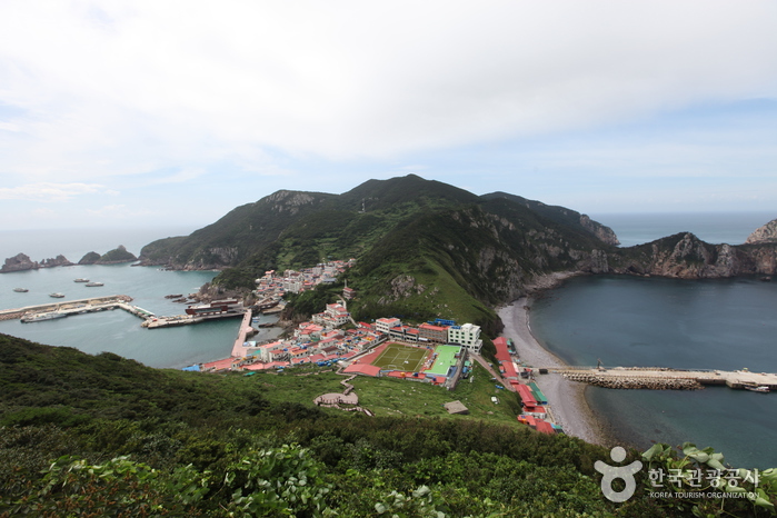 Hongdo Island (홍도)
Times and difficulty are estimates from GPS tracks. Before you go, check the weather, sunset time and any trail closures. Course tracks recorded: 2022-01-06
Text on this page was translated automatically from Korean public data. Place names follow the Revised Romanization; signs on the trail are in Korean.
Data: Korea Forest Service and Korea Hiking & Trekking Support Center (Public Data Portal). Course times and difficulty are estimates from GPS tracks (2022).