
Deogyusan 1,614m
A grand mountain of deep ridges and layered virtue
Easy Moderate Hard Valleys Public transport


- Location
- Muju-gun and Jangsu-gun in Jeollabuk-do, Geochang-gun and Hamyang-gun in Gyeongsangnam-do
- Courses
- 10 · 2 h 40 min – 6 h 10 min
- Distance
- 6.1 km – 10 km
- Facilities
- Toilets 16 · Parking 4
- Managed by
- Muju County Office · 063-320-2114
Trail map
Why it is one of the 100 famous mountains
Selected for forming a grand 17km mountain ridge from Hyangjeokbong Peak to Namdeogyu, serving as the headwaters of the Geumgang and Nakdonggang Rivers, and being designated as a National Park (1975). It is also renowned for the approximately 30km-long Muju Gucheondong Valley flowing to the north, its natural recreation forest, and Baegnyeonsa Temple, founded in 830 (the 5th year of King Heungdeok of Silla) by Master Muyeom.
About Deogyusan
This mountain is widely known for the 33 scenic views of Muju Gucheondong. Starting from the 1st view, Najetongmun Gate, the valley unfolds through scenic spots such as Haksodae, Chuwoldam, Susimdae, Inwoldam, Geumpotan, and Gucheon Falls, spanning an estimated 9,000 winding turns. The 31st view is Isokdae, the 32nd is Baegnyeonsa Temple, and the 33rd is Hyangjeokbong Peak... representing a journey of "leaving the secular world, passing a temple resembling a white lotus, and ascending a peak where exquisite fragrance accumulates like a mountain."
However, the true meaning of its name—a mountain of generous virtue—is best felt on the southeastern foothills toward Geochang. The grand, bow-shaped ridge blocks the northwestern winds while the southeastern winds bring ample rain, resulting in vegetation richer than in any other area. Thanks to this, crops flourish and the scenery is magnificent, dotted with exquisite pavilions like Cheongsajeong, Moamjeong, Yongamjeong, and Suseungdae. It is impossible to truly discuss Deogyusan without seeing Buksang-myeon in Geochang.
Deogyusan spans the borders of Muju-gun and Jangsu-gun in Jeonbuk, and Geochang-gun and Hamyang-gun in Gyeongnam, covering 2 provinces, 4 counties, and 8 townships. It is the 4th highest mountain in South Korea after Hallasan, Jirisan, and Seoraksan, and is a massive mountain boasting more than 20 peaks exceeding 1,000 meters.
The name Deogyu signifies a grand and generous mountain endowed with virtue. It is said that Monk Muhak discovered Deogyusan while searching for a deep, scenic mountain escape away from troubled political regimes.
Courses recommended by the Korea Forest Service
- Samgong-ri → Chilbong Peak → Hyangjeokbong Peak → Jungbong Peak → Osujagul Cave → Baegnyeonsa Temple → Samgong-ri 5 h 20 min
- Songgyesa Temple → Gwibong Peak → Baegambong Peak → Jungbong Peak → Hyangjeokbong Peak → Baegnyeonsa Temple → Samgong-ri 4 h 40 min
- Myeongcheon-ri → Satgatgoljae Pass → Wolseongjae Pass → Namdeogyusan Mountain → Yeonggaksa Temple 5 h 45 min
Public transport
The main base is Muju. Buses to Gucheondong run every 20 minutes. Muju has convenient connections to the Gyeongbu Line, with buses running 54 times daily from Daejeon and 32 times from Yeongdong. Express buses run 5 times daily from Seoul Nambu Terminal, and buses also operate from Daegu, Gwangju, and Cheongju.
For the southeastern trailheads, buses to Songgyesa Temple, Byeonggok, Sansu, and Hwangjeom run from Geochang 9, 3, 3, and 6 times daily, respectively. To Geochang, buses run 8 times from Dong Seoul Terminal and 14 times (including 2 late-night buses) from Nambu Terminal. From outside Gyeongnam, buses run from Daegu, Incheon, Gwangju, Daejeon, Jeonju, and Gimcheon.
Toward Yeonggaksa Temple, the southernmost point, local buses run 6 times daily from Hamyang. Direct buses to Hamyang operate 10 times from Dong Seoul Terminal and 10 times (including 2 late-night buses) from Nambu Terminal. From outside Gyeongnam, buses run from Daegu, Incheon, Gwangju, Daejeon, Suwon, Jeonju, and Gimcheon.
Food, lodging & more (Korea Forest Service data, may change)
● Lodging and Other Info
Muju Resort (☎063-322-9000) and Deogyusan Natural Recreation Forest (☎063-322-1097) are ideal options.
Along the main ridge, Satgatjae Shelter (☎011-423-1452) and Hyangjeokbong Shelter (☎063-322-1614) are available.
● Inquiries
Deogyusan National Park Office ☎063-322-3174~5
Nearby attractions
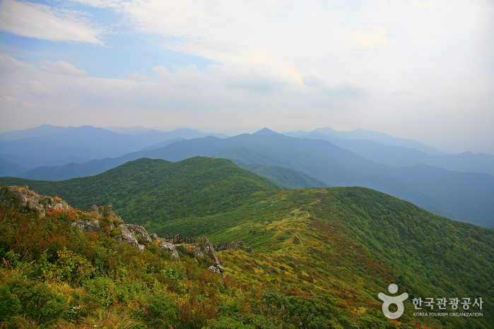 Hyangjeokbong Peak (Deogyusan Mountain) (향적봉(덕유산))
Times and difficulty are estimates from GPS tracks. Before you go, check the weather, sunset time and any trail closures. Course tracks recorded: 2022-01-06
Text on this page was translated automatically from Korean public data. Place names follow the Revised Romanization; signs on the trail are in Korean.
Data: Korea Forest Service and Korea Hiking & Trekking Support Center (Public Data Portal). Course times and difficulty are estimates from GPS tracks (2022).