
Cheongnyangsan 870m
A Treasure Trove of Beautiful Tourism Resources
Easy Moderate Autumn foliage


- Location
- Myeongho-myeon and Jaesan-myeon, Bonghwa-gun, and Dosan-myeon and Yean-myeon, Andong-si, Gyeongsangbuk-do
- Courses
- 3 · 2 h 45 min – 2 h 55 min
- Distance
- 4.7 km – 6.7 km
- Facilities
- Toilets 8 · Parking 5
- Managed by
- Bonghwa County Office · 054-679-6114
Trail map
Why it is one of the 100 famous mountains
Selected because although not vast in scale, its continuous rocky peaks and sheer cliffs have earned it the nickname Sogeumgang (Little Geumgang) for its scenic landscape since ancient times, and it was designated a provincial park in 1982. It is renowned for historic sites, including Yuribojeon Hall founded by Monk Wonhyo, Oecheongnyangsa Temple from the Silla period, Goundae Terrace and Dokseodang Study associated with Choe Chi-won, Omadae Platform and Cheongnyangsanseong Fortress where King Gongmin took refuge during the Red Turban Invasions, Gim Saeng Cave where master calligrapher Gim Saeng studied, and Osandang (Cheongnyangjeongsa House) where Toegye Yi Hwang studied and synthesized Neo-Confucianism.
About Cheongnyangsan
Cheongnyangsan is a celebrated mountain along the Nakdonggang River often compared to a single lotus blossom. While such descriptions are usually exaggerations, it holds true here. Cheongnyangsa Temple rests snugly in the center, surrounded like petals by Chukyungbong, Gyeongilbong, Bosalbong, and the summit Janginbong Peaks enclosing Geumtapbong Peak.
Its elevation is higher than Samgaksan in Seoul. In addition, its primary peaks are massive rock formations lightly draped in greenery, presenting outstanding craggy scenery. Bosalbong Peak is steep enough to require rock climbing gear to ascend. Despite this ruggedness, the mountain area is compact enough to tour in half a day.
When traversing the ridge counterclockwise, the view of the Nakdonggang River from the summit finish is open and refreshing. Gwangseongnaru Ferry below is regarded as one of the river's finest scenic viewpoints, both historically and today across the bridge.
Seen from the outside, the mountain looks like an ink landscape painting. Witdwitsil Village in Bukgok-ri serves as a viewpoint where the dark, bluish hues of the rock wall against the backlit skyline leave a lasting impression.
Located 26 km southeast of Bonghwa-eup, Cheongnyangsan (869.7m) features 12 scenic peaks, including Geumtapbong Peak, and 8 caves.
Known as Sogeumgang (Little Geumgang) since ancient times for its exquisite scenery, the mountain overlooks the Nakdonggang River originating from Taebaeksan Mountain as it wraps around shear cliffs. It comprises 12 peaks of bizarre rock formations, including Sinseondae Terrace, where Daoist hermits played baduk (Go), and Seonnyeobong Peak, where heavenly maidens sang and danced. It is also renowned as a birthplace of Confucian, Buddhist, and Daoist thought where ancient sages like Gim Saeng and Toegye Yi Hwang practiced asceticism from the Silla period to modern times. In the 10th year of King Gongmin of Goryeo, the king took refuge here during the Second Red Turban Invasion and built a mountain fortress as a last bastion. Legend holds that after the king departed, villagers built King Gongmin Shrine (Gongminwangdang) to hold memorial rites in spring and autumn, and during times of great turmoil, echoing sounds would ring out to help ward off disasters. The trail ascending to this shrine includes the Omado Path, wide enough for five horses to pass abreast.
Courses recommended by the Korea Forest Service
- Witdwitsil → 795m Peak → Summit → 795m Peak → Cheongnyangsa Temple → Cheongnyang Village 3 h 50 min
- Ireumsil → Multijae Pass → Cheongnyangsan Rest Area → Chukyungbong Peak → Cheongnyangsan Rest Area → Cheongnyang Village 3 h
Public transport
Bonghwa is the base point from the north, and Andong from the south.
> Bonghwa → Cheongnyangsan: 4 times daily
> Andong → Cheongnyangsan: 6 times daily
Food, lodging & more (Korea Forest Service data, may change)
● Food, Lodging & Other Information
There are two traditional hanok homestays in Chunyang-myeon, relatively close to the mountain: Gwon Jinsadaek (☎ 054-672-6118) and Mansan Gotaek (☎ 054-672-3206). Both provide flush toilets and shower facilities.
Cooking is possible, meals can be requested, and foreign guests are welcome.
● Inquiries
Cheongnyangsan Provincial Park Management Office ☎ 054-679-6321
Nearby attractions
-
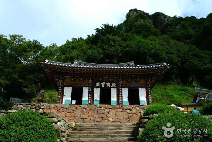 Bonghwa Cheongnyangsa Temple (청량사(봉화))
1.2 km from the summit
-
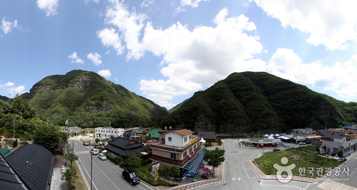 Cheongnyangsan Provincial Park (청량산도립공원)
1.3 km from the summit
-
 Gosanjeong Pavilion (고산정)
3.2 km from the summit
- Nongam Head House (농암종택) 3.9 km from the summit
- Menge Village (맹개마을) 4 km from the summit
-
 Dosanseowon Confucian Academy [UNESCO World Heritage] (도산서원 [유네스코 세계유산])
9.4 km from the summit
Times and difficulty are estimates from GPS tracks. Before you go, check the weather, sunset time and any trail closures. Course tracks recorded: 2022-01-06
Text on this page was translated automatically from Korean public data. Place names follow the Revised Romanization; signs on the trail are in Korean.
Data: Korea Forest Service and Korea Hiking & Trekking Support Center (Public Data Portal). Course times and difficulty are estimates from GPS tracks (2022).