
Bangjangsan 734m
Hideout of bandits who robbed travelers' bundles
Moderate Valleys Sea views Public transport


- Location
- Sillim-myeon, Gochang-gun and Ibam-myeon, Jeongeup-si, Jeollabuk-do; Jangseong-gun, Jeollanam-do
- Courses
- 3 · 3 h 15 min – 4 h 30 min
- Distance
- 6 km – 10.1 km
- Facilities
- Toilets 1 · Parking 5
- Managed by
- Gochang County Office · 063-564-2121
Trail map
Why it is one of the 100 famous mountains
Historically revered alongside Jirisan and Mudeungsan as one of the Three Sacred Mountains of the Honam region, it was designated for its majestic mountain landscape that divides Jeonbuk and Jeonnam, as well as its natural recreation forest. Its ancient name is Bangdeungsan, which is the setting for the Baekje folk song 'Bangdeungsanga.' From the summit, the West Sea is visible in the distance and Mudeungsan can be seen to the east.
About Bangjangsan
Traveling south along the Honam Expressway, the Honam Plain ends and the road enters the mountains. On the left, Nongbawi Rock at the summit of Ibamsan is as striking as a literary painting, while on the right, a magnificent mountain rises like a great canvas curtain. This is Bangjangsan.
Rising steeply from the flatlands, its ridges are simple, looking as if drawn with a single stroke of a brush. The panoramic view is excellent, offering vivid map-like sights of downtown Gochang, the surrounding plains, and the local attraction Moyangseong Fortress. Although its name literally means 'elder of a Buddhist temple,' it has no relation to one. During the Baekje period, it was called Bangdeungsan, which likely shifted phonetically over time to Bangjeungsan and then Bangjangsan. 'Bang' means square or region, so it might have originally been Modeung, which connects to Moyangburi, the ancient name of Gochang, meaning the 'back ridge of Moyang.'
Byeogobong Peak, situated southwest of the main peak, is sometimes mistakenly called Bangmunsan, but this is an absurd error. The boundary between the 1:50,000 national topographic maps of 'Gochang' and 'Damyang' passes between the two peaks. While the name was printed correctly on the 'Damyang' map showing the main peak, a typesetter for the old 'Gochang' map mistakenly inserted the character 'mun' (文) instead of 'jang' (丈), producing Bangmunsan. Unaware of this, many people still refer to it as Bangmunsan, much like how the highest peak of Byeonsan, Uisangbong, was misread and called Gisangbong for a long time.
Bangjangsan rises on the border of Jeongeup and Gochang in Jeonbuk, and Jangseong in Jeonnam. It is the highest peak among the ridges stretching along the western spur of Naejangsan.
Along with Jirisan and Mudeungsan, it has long been revered as one of the Three Sacred Mountains of the Honam region. Even though surrounded by renowned mountains like Naejangsan, Seonunsan, and Baegamsan, it maintains an imposing, undaunted presence. The Bangjangsan Natural Recreation Forest is located on its mid-slope.
Opened on July 1, 2000, it is managed by the Western Regional Forest Service alongside recreation forests at Hoemunsan, Deogyusan, Unjangsan, Cheongwansan, Jirisan, and Namhae Cypress. The forest features abundant oak, pine, cypress, larch, and pitch pine trees. Following the forest road toward Gochang leads to a ridge between Byeogobong Peak (640m) and Gochanggogae Pass, overlooking downtown Gochang and the West Sea. Continuing slightly past Gochanggogae Pass toward Jangseonggaljae leads to the summit of Bangjangsan.
Reaching the summit offers scenery fit for immortals, with views extending over downtown Gochang, vast developed hill lands, the distant West Sea, and Mudeungsan in Gwangju to the east. A round trip from the recreation forest to the summit takes about 3 hours, and a trail also leads directly down to Seokjeong Hot Springs.
Upon reaching the main ridge, hikers can enjoy cool breezes blowing from the West Sea, making it a popular spot for paragliders. Yongchu Falls is situated in Yongchugol Valley west of the summit, and Seokjeong Hot Springs, famous for its germanium-rich water, sits at the descent point to relieve fatigue. Gochang is also well known for its traditional food.
Courses recommended by the Korea Forest Service
- Sinpyeong-ri → Yongchu Falls → Gochanggogae Pass → Summit → Bongsudae → Ridge 3-way Junction → Yongchu Falls → Sinpyeong-ri 3 h
- Yanggosaljae Pass → Bangjangsa Temple → 579m Peak → Byeogobong Peak → West Ridge → Mireuksa Temple → Sangwol Village 3 h
- Recreation Forest → Gochanggogae Pass → Summit → Bongsudae → 734m Peak → Sogaljae Pass → Yeonwol-ri 3 h 20 min
Public transport
Gochang serves as the base. Buses from Gochang to Sangwol, Wolam, or Seokjeong Hot Springs run at 30-minute intervals; for Sinpyeong-ri, take the bus bound for Jeongeup (6 runs daily).
Express buses run 16 times daily from Seoul Central City Terminal (Gangnam) to Gochang. Outside Jeollabuk-do, buses also operate from Gwangju and Mokpo.
To reach the recreation forest, take a taxi from Baegyangsa Station on the Honam Line. If starting or ending the hike at Galjae Pass, take a taxi from Jeongeup.
Food, lodging & more (Korea Forest Service data, may change)
● Accommodation & Information
Lodging is available in downtown Gochang.
Dongbang Hotel ☎063-563-7070,
Green Park Motel ☎063-562-5900,
Walkerhill Motel ☎063-561-5358, etc.
Bangjangsan Natural Recreation Forest offers cabins ranging from 23 to 66 m². ☎061-394-5523
● Inquiries
Buan County Office Culture and Tourism Division ☎063-580-4191
Jangseong County Office Culture and Tourism Division ☎061-390-7224
Nearby attractions
-
 National Center for Forest Activities, Jangseong (국립장성숲체원)
1.3 km from the summit
-
 Bangjangsan National Recreational Forest (국립 방장산자연휴양림)
1.4 km from the summit
- Gochang Wellparkcity (고창웰파크시티) 2.9 km from the summit
-
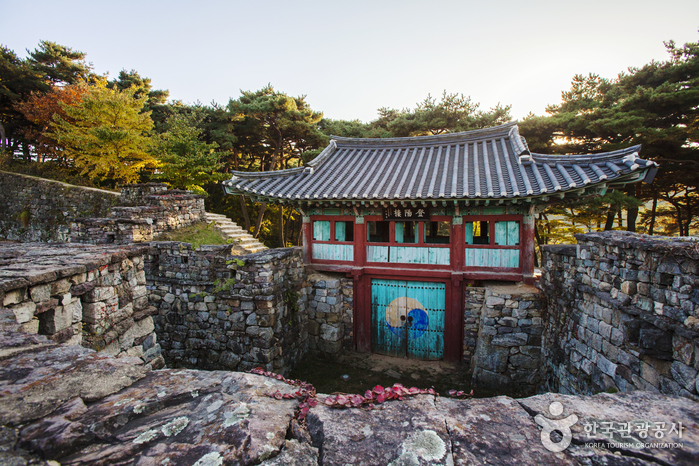 Gochangeupseong Walled Town (고창읍성)
5.3 km from the summit
- Namchanggyegok Valley (남창계곡) 7.9 km from the summit
- Ungok Ramsar Wetland (고창 운곡람사르습지) 9.2 km from the summit
Times and difficulty are estimates from GPS tracks. Before you go, check the weather, sunset time and any trail closures. Course tracks recorded: 2022-01-06
Text on this page was translated automatically from Korean public data. Place names follow the Revised Romanization; signs on the trail are in Korean.
Data: Korea Forest Service and Korea Hiking & Trekking Support Center (Public Data Portal). Course times and difficulty are estimates from GPS tracks (2022).