
Baegunsan (Jeongseon) 884m
A Pristine Haven Preserving Primordial Mystique
Moderate Hard Public transport


- Location
- Sindong-eup, Jeongseon-gun and Mitan-myeon, Pyeongchang-gun, Gangwon-do
- Courses
- 2 · 4 h 25 min – 5 h 10 min
- Distance
- 8.2 km – 10.6 km
- Facilities
- Toilets 2 · Parking 2
- Managed by
- Jeongseon County Office · 033-562-3911
Trail map
Why it is one of the 100 famous mountains
Selected for its scenic beauty situated along the central Donggang River, its expansive viewpoints, and its designation as an ecological conservation area. The name Baegunsan originates from the white clouds that perpetually shroud its peaks. It is renowned for the Donggang River, which gathers the Odaecheon Stream (originating from Odaesan) and Joyanggang River before flowing into the Namhangang River, as well as the Baengnyong Cave (designated as Natural Monument No. 260 in 1979).
About Baegunsan (Jeongseon)
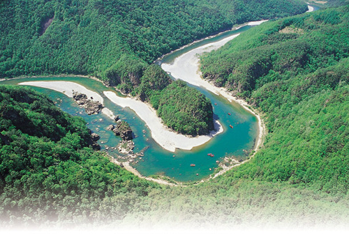
Baegunsan overlooks the Donggang River, an area once central to national debates over a planned dam project. It offers stunning views of dramatic incised meanders, and hikers can enjoy rafting before or after the trek.
The Yongga Ridge extending to the south and the Chiljongnyeong Ridge extending southwest appear to clutch the patchwork fields of Sodong Village and the pseudo-islands shaped by paleochannels across the river. The Yongga Ridge resembles a dog's foot, gradually lowering and narrowing before flattening at the end, while the Chiljongnyeong Ridge features six peaks jagged like glass shards atop a wall.
Standing at the summit, the sweeping meanders of the Donggang River unfold in full view. Hikers can see nearby peaks like Wantaeksan, Gogosan, Gyebong, and Gombong, as well as Hambaeksan in the distance.
However, because it is a limestone mountain, there are many sheer, cliff-like precipices. Known in local dialect as 'ppyeongdae,' these cliffs see occasional slipping accidents, requiring extra caution.
A prime vantage point looking across at Baegunsan is Goseongsanseong Fortress (425m) south of Sodong Village. This stone fortress, believed to have been built by the Goguryeo Kingdom, offers breathtaking views of the area and prompts wonder about why a fortress was constructed deep within such rugged mountain gorges.
Flanked by the Donggang River, Baegunsan carries an aura of primordial mystique and pristine natural beauty, with the river quietly winding deep within Gangwon-do's mountains. Perhaps because of this, hiking Baegunsan can feel like stepping into the realm of an immortal hermit.
A hike on Baegunsan requires crossing the Donggang River, both at the start and at the finish. Alternatively, hikers can descend from Chiljongnyeong Pass to Munhui Village without crossing water on foot, and instead take a boat down to Seobsae to enjoy both the mountain and the river. Nonetheless, starting the hike at Jeomjae Village is the most common route.
Courses recommended by the Korea Forest Service
- Munhui Village → Chiljongnyeong Pass → Summit → 955m Peak → Pyotdaebong Peak → 955m Peak → Southwest Ridge → Munhui Village 6 h 40 min
- Jeomjae Village → Valley Trail → Summit → Gureumjaegol Valley → Munhui Village 3 h 20 min
- Jejang Village → Chiljongnyeong Pass → Summit → Valley Trail → Jeomjae Village 4 h 30 min
Public transport
Unlike its administrative jurisdiction, the practical trailheads start from Sindong-eup, Yeongwol-gun. Take the bus bound for Unchi-ri in front of Yemi Station and get off at the last stop, Jeomjae Ferry. The Taebaek Line train from Cheongnyangni runs to Yemi Station 5 times daily. For Sindong, take the direct bus bound for Taebaek from East Seoul Bus Terminal (11 times daily) or from Yeongwol (28 times daily). Buses connect to Yeongwol from Chuncheon, Wonju, Gangneung, Daegu, Incheon, Suwon, Seongnam, Uijeongbu, Ansan, Goyang, and Cheongju.
Food, lodging & more (Korea Forest Service data, may change)
● Lodging and Dining Info
Use accommodations in Yeongwol town or guesthouses at the foot of the mountain. Yeongwol town: Grand Park Motel (033-373-6110), Jangneung Motel (033-373-8890). Jeomjae Village: Jeomjae Store (033-378-1570). Jejang Village: Eunha Rest Area (033-378-8765). Munhui Village: Donggang Mountain Cabin (033-333-9509).
● Inquiries
Pyeongchang County Office Culture and Tourism Division: 033-330-2540
Nearby attractions
-
 Baengnyongdonggul Cave [Gangwon Paleozoic Geopark] (백룡동굴 (강원고생대 국가지질공원))
2.4 km from the summit
- Pyeongchang Eoreumchi Village (평창 어름치마을) 3.4 km from the summit
-
 Eorayeon Valley -Gangwon Paleozoic Geopark (어라연-강원고생대 국가지질공원)
8.1 km from the summit
-
 Byeongbangchi Skywalk (병방치 스카이워크)
8.6 km from the summit
Times and difficulty are estimates from GPS tracks. Before you go, check the weather, sunset time and any trail closures. Course tracks recorded: 2022-01-06
Text on this page was translated automatically from Korean public data. Place names follow the Revised Romanization; signs on the trail are in Korean.
Data: Korea Forest Service and Korea Hiking & Trekking Support Center (Public Data Portal). Course times and difficulty are estimates from GPS tracks (2022).